By Bryan Gentry
On Lynchburg’s bloodiest days in the Civil War, Confederate soldiers marched uphill from the downtown area to drive back invading Union troops.

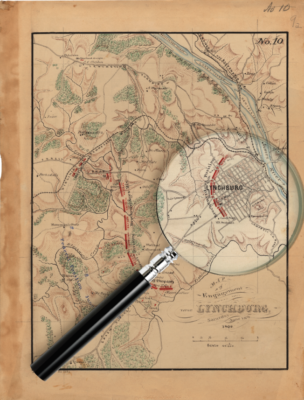
On the second day of the Battle of Lynchburg in June 1864, the troops fought in and around a forested area that is now the University of Lynchburg campus. The Union started giving way in the unfamiliar, hilly terrain, but John Mostoller of Pennsylvania led his fellow Union soldiers in storming up a hill and seizing a Confederate cannon.
A mile and a half away, Union Gen. David Hunter led the strategy of the battle from Sandusky, a home he had commandeered as a headquarters.
This spring, that same house was home base for Tyler Wilson ’16, ’19 MEd as he worked to make the two-day Battle of Lynchburg a little more accessible to modern historians.
Using geographic information systems, or GIS, Wilson tied historic maps, new photos, and stories from Lynchburg history together with modern maps. The result is a series of online, interactive maps that work like a time machine, allowing you to see how the city developed over the past 200 years. You can find a point of interest (your house, for example) and see what was there in 1864,
and get an idea for how closely troops passed by during the Civil War.
“GIS allows us to digitize the old maps, pull the features off of them, and use those against modern maps and do all sorts of analysis,” Wilson said.
Wilson originally came to Lynchburg for an environmental science degree. Then he took Dr. David Perault’s classes on remote sensing and GIS and said he “fell in love” with the technology. A year after he graduated, he came back to earn a master’s degree in science education.
He got a graduate assistant job at Historic Sandusky, which is now a museum owned and operated by the University. “I didn’t get to work with GIS too much during my year off,” he said. “When the opportunity presented itself to get to work with it again on a project here, it was really appealing to me.”
“This started as a Civil War-themed project, but there’s so much besides the two-day battle. We’ll broaden it to all of the 19th century, as much as we can fit in it.”
– Greg Starbuck ’14 MA, ’19 MA
The project started with an 1864 map showing troop movements in the Battle of Lynchburg. Wilson laid a high-resolution scan of that map over a modern map with satellite imagery. He aligned street intersections that existed on both maps, and the computer program stretched the old map to make those points match up. Then Wilson added interactive components, such as clickable points that bring up photos or stories related to particular parts noted on the map.
In addition to the Battle of Lynchburg map, Wilson has been working on an interactive version of an 1885 fire insurance map, which shows the city’s firefighting capabilities but also identifies several buildings and their uses. Other maps show urban sprawl or focus more on railroads.
“This started as a Civil War-themed project, but there’s so much besides the two-day battle,” Greg Starbuck ’14 MA, ’19 MA, director of Historic Sandusky, said. “We’ll broaden it to all of the 19th century, as much as we can fit in it.”
Other students have helped by building a collection of more than 100 historic photos of different buildings in Lynchburg, as well as stories related to different points of interest. Those are being paired with photos of the same scenes from similar angles, and Wilson’s map makes them available to all.
“We’re trying to provide the perspective from both the mapping standpoint and the visual standpoint,” Perault said.
Since the University partnered with, and eventually acquired, Historic Sandusky, students have spent time there as interns, graduate assistants, or paid employees in an archeology lab. Some are history students, but quite a few, like Wilson, have science backgrounds.
“The environmental science department’s been a good conduit for students for us,” Starbuck said.

